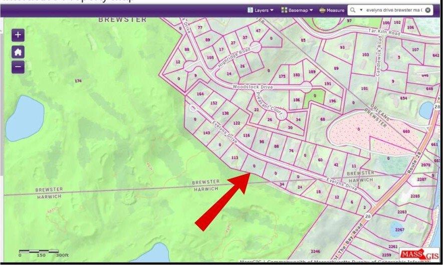
0 Evelyns Drive, Brewster, MA 02631
$275,000
0.52 acres
Estimated Payment
$ 1,541 /mo. †
6.67%
APR for
30 yrs.
$1,512 in taxes
Change Loan Terms
-
Other Residential
Property type -
0.5 acres
Lot size
Explore this Property
Courtesy Of MA Realty Partners LLC, DBA Keller Williams Realty, Mid Upper Cape Cod
(508) 534-7200
Property Features
-
Architecture StyleOther
-
Lot Size0.52 Acres
Home seller CENTURY 21 North East
Get to know the neighborhood. A local affiliated CENTURY 21 office will help you set up tours, give advice, and negotiate with sellers.
CENTURY 21 North East
(800) 844-7653Mortgage Calculator
Monthly Payment Breakdown
-
Principle and Interest
$1,415
-
Property Taxes
$126
-
Hazard Insurance
$0
-
Private Mortgage Insurance
$0
-
HOA Dues
$0
-
Total Monthly Payment:
$1,541
Calculators provided for estimating purposes only. Consult with your lender to determine precise payment requirements.
Schools
Stony Brook Elementary School
Grades PK-2 Public School
Brewster, MA 02631
4.2 miles
384 underpass rd
211 total students
9:1 Student teacher ratio
Eddy Elementary School
Grades 3-5 Public School
Brewster, MA 02631
4.4 miles
2298 main st
209 total students
9:1 Student teacher ratio
Nauset Regional Middle School
Grades 6-8 Public School
Orleans, MA 02653
3.8 miles
70 s orleans rd
571 total students
11:1 Student teacher ratio
Nauset Regional High School
Grades 9-12 Public School
North Eastham, MA 02651
9.1 miles
100 cable rd
855 total students
11:1 Student teacher ratio
| Other Nearby Schools | Distance | Type | Grades | School Rating |
|---|---|---|---|---|
| Cape Cod Lighthouse Charter School | 1.9 miles | Public | 6-8 | B
|
| Monomoy Regional Middle School | 2.7 miles | Public | 5-7 | B-
|
| The Laurel School | 2.8 miles | Private | PK-5 | |
| Chatham Elementary School | 3.5 miles | Public | PK-4 | B-
|
| Orleans Elementary School | 3.6 miles | Public | KG-5 | A
|
| Cape Cod Region Vocational Technical | 4.2 miles | Public | 9-12 | B+
|
| Monomoy Regional High School | 4.5 miles | Public | 8-12 | B
|
| Latham School | 5.2 miles | Private | 4-12 | |
| Harwich Elementary School | 5.4 miles | Public | PK-4 | C+
|
School information does not guarantee enrollment. School service boundaries are provided as a reference only, may change, and are not guaranteed to be accurate. Contact the school district directly to verify school enrollment eligibility.
Local area information for Brewster, MA 02631

Tour the area
Schedule a
tour with a
personal guide
Brewster, MA 02631
This community’s employment is highest in the education and administrative support industries. The area’s overall household expenses are above the national average.

have children
Household Expenses vs National Average
Demographic facts
for Brewster, MA 02631
Brewster, MA 02631 has a population of 10,444 people in 4,878 households with a median age of 57.1 years old.

since the year 2010
Population is Trending up
households in 5 years
Community Population By Age
Community Population By Ethnicity
| White | 91% |
| Hispanic | 3% |
| Black | 2% |
| Asian | 1% |
| Other | 1% |
| Native American | <1% |
Economics
for Brewster, MA 02631

Household Expenses vs National Average
Household by Income
Transportation to Work
- Drive 89%
- Work from Home 6%
- Walk or Bike 4%
- Public Transit 0%
Occupancy by Type
| Owned | 4,074 | 49% |
| Vacant | 3,375 | 41% |
| Rented | 803 | 10% |
White vs Blue Collar Jobs
| White Collar | 69% |
| Blue Collar | 31% |
Family & Education Facts
for Brewster, MA 02631

Average Household Size
household
59.2%
Community Population By Education
| Graduate Degree | 24% |
| Bachelors Degree | 22% |
| High School Graduate | 21% |
| Some College | 20% |
| Associates Degree | 10% |
| Some High School | 3% |
Household Family Expenses vs National Average
Weather
for Brewster, MA 02631
The weather for this area ranges from a high of 77° F in July to a low of 24° F in January

Average Temperature by Month
Average Temperature in Degrees Fahrenheit
Precipitation
| Precipitation (inch) |
Tour the area
Schedule a
tour with a
personal guide
There's more to learn about Brewster, MA 02631!
Explore more
local area information
Copyright © 2025 Cape Cod & Islands Association of REALTORS®, Inc. All rights reserved. All information provided by the listing agent/broker is deemed reliable but is not guaranteed and should be independently verified. Information being provided is for consumers' personal, non-commercial use and may not be used for any purpose other than to identify prospective properties consumers may be interested in purchasing. Information being provided is for consumers' personal, non-commercial use and may not be used for any purpose other than to identify prospective properties consumers may be interested in purchasing.
Data powered by Attom Data Solutions. Copyright© 2025. Information deemed reliable but not guaranteed.
This information is provided for general informational purposes only and should not be relied on in making any home-buying decisions. School information does not guarantee enrollment. Contact a local real estate professional or the school district(s) for current information on schools. This information is not intended for use in determining a person's eligibility to attend a school or to use or benefit from other city, town or local services.
† Based on a 30-year fixed rate of 3.38% with 20% down. The estimated payment is offered for convenience and is not an offer of credit. Due to market fluctuations, interest rates are subject to change at any time and without notice. Interest rates are also subject to credit and property approval based on secondary market guidelines. The rates shown are based on average rates for our best qualified customers. Your individual rate may vary. Rates may differ for FHA, VA or jumbo loans.

0 Evelyns Drive
Brewster, MA 02631
0 Evelyns Drive
Brewster
, MA 02631

Brewster, MA 02631
Courtesy Of MA Realty Partners LLC, DBA Keller Williams Realty, Mid Upper Cape Cod
Request Information
Brewster, MA 02631
Courtesy Of MA Realty Partners LLC, DBA Keller Williams Realty, Mid Upper Cape Cod
Request a tour of this property
Brewster, MA 02631
Courtesy Of MA Realty Partners LLC, DBA Keller Williams Realty, Mid Upper Cape Cod