12 King Street, Northborough, MA 01532
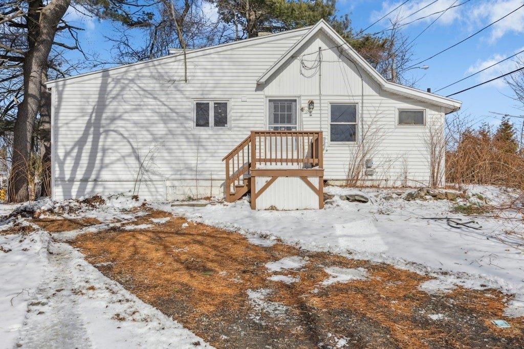
$2,000
2 beds • 1 baths • 1,000 sqft
-
Single Family Detached
Property type -
$2.00
Price per square foot
Explore this Property
Courtesy Of Pinnacle Metrowest LLC DBA Keller Williams Pinnacle Metrowest
(508) 754-3020
Property Features
-
Architecture StyleOther
Home seller CENTURY 21 North East
Get to know the neighborhood. A local affiliated CENTURY 21 office will help you set up tours, give advice, and negotiate with sellers.
CENTURY 21 North East
(800) 844-7653Schools
Fannie E Proctor
Grades KG-5 Public School
Northborough, MA 01532
0.4 miles
26 jefferson rd
238 total students
12:1 Student teacher ratio
Robert E. Melican Middle School
Grades 6-8 Public School
Northborough, MA 01532
0.9 miles
145 lincoln st
517 total students
10:1 Student teacher ratio
Algonquin Regional High School
Grades 9-12 Public School
Northborough, MA 01532
2.6 miles
79 bartlett st
1355 total students
12:1 Student teacher ratio
| Other Nearby Schools | Distance | Type | Grades | School Rating |
|---|---|---|---|---|
| Lincoln Street | 0.6 miles | Public | KG-5 | B
|
| Marion E Zeh | 1.3 miles | Public | KG-5 | B
|
| Marguerite E Peaslee | 1.8 miles | Public | KG-5 | A
|
| The Fitzgerald Institute | 2.2 miles | Private | PK-5 | |
| St Bernadette Elementary School | 2.3 miles | Private | PK-8 | |
| Spring Street School | 2.3 miles | Public | KG-4 | B
|
| Floral Street School | 2.5 miles | Public | KG-4 | A
|
| Al-hamra Academy | 2.8 miles | Private | PK-8 | |
| St Mary Elementary School | 2.8 miles | Private | PK-8 | |
| Central Area | 2.9 miles | Public | ||
| West Area | 2.9 miles | Public | ||
| Southeast Area | 2.9 miles | Public | ||
| East Area | 2.9 miles | Public | ||
| Lilliput Early Childhood Center | 3 miles | Private | PK-1 | |
| Sarah W. Gibbons Middle School | 3 miles | Public | 7-8 | B+
|
| Walter J. Paton Elementary School | 3 miles | Public | KG-4 | A
|
| J. Harding Armstrong Elementary School | 3.1 miles | Public | KG-3 | C
|
School information does not guarantee enrollment. School service boundaries are provided as a reference only, may change, and are not guaranteed to be accurate. Contact the school district directly to verify school enrollment eligibility.
Local area information for Northborough, MA 01532

Tour the area
Schedule a
tour with a
personal guide
Northborough, MA 01532
This community’s employment is highest in the administrative support and sales industries. The area’s overall household expenses are above the national average.

have children
Household Expenses vs National Average
Demographic facts
for Northborough, MA 01532
Northborough, MA 01532 has a population of 15,801 people in 5,727 households with a median age of 42.6 years old.

since the year 2010
Population is Trending up
households in 5 years
Community Population By Age
Community Population By Ethnicity
| White | 75% |
| Asian | 13% |
| Hispanic | 4% |
| Other | 2% |
| Black | 2% |
| Native American | <1% |
Economics
for Northborough, MA 01532

Household Expenses vs National Average
Household by Income
Transportation to Work
- Drive 79%
- Work from Home 18%
- Walk or Bike 2%
- Public Transit 2%
Occupancy by Type
| Owned | 4,795 | 81% |
| Rented | 931 | 16% |
| Vacant | 205 | 3% |
White vs Blue Collar Jobs
| White Collar | 93% |
| Blue Collar | 7% |
Family & Education Facts
for Northborough, MA 01532

Average Household Size
household
67.8%
Community Population By Education
| Graduate Degree | 37% |
| Bachelors Degree | 32% |
| High School Graduate | 12% |
| Some College | 11% |
| Associates Degree | 6% |
| Some High School | 2% |
Household Family Expenses vs National Average
Weather
for Northborough, MA 01532
The weather for this area ranges from a high of 83° F in July to a low of 14° F in January

Average Temperature by Month
Average Temperature in Degrees Fahrenheit
Precipitation
| Precipitation (inch) |
Tour the area
Schedule a
tour with a
personal guide
There's more to learn about Northborough, MA 01532!
Explore more
local area information
Copyright © 2025 MLS Property Information Network Inc. All rights reserved. All information provided by the listing agent/broker is deemed reliable but is not guaranteed and should be independently verified. Information being provided is for consumers' personal, non-commercial use and may not be used for any purpose other than to identify prospective properties consumers may be interested in purchasing. Information being provided is for consumers' personal, non-commercial use and may not be used for any purpose other than to identify prospective properties consumers may be interested in purchasing.
Data powered by Attom Data Solutions. Copyright© 2025. Information deemed reliable but not guaranteed.
This information is provided for general informational purposes only and should not be relied on in making any home-buying decisions. School information does not guarantee enrollment. Contact a local real estate professional or the school district(s) for current information on schools. This information is not intended for use in determining a person's eligibility to attend a school or to use or benefit from other city, town or local services.
† Based on a 30-year fixed rate of 3.38% with 20% down. The estimated payment is offered for convenience and is not an offer of credit. Due to market fluctuations, interest rates are subject to change at any time and without notice. Interest rates are also subject to credit and property approval based on secondary market guidelines. The rates shown are based on average rates for our best qualified customers. Your individual rate may vary. Rates may differ for FHA, VA or jumbo loans.

12 King Street
Northborough, MA 01532
12 King Street
Northborough
, MA 01532

Northborough, MA 01532
Courtesy Of Pinnacle Metrowest LLC DBA Keller Williams Pinnacle Metrowest
Request Information
Northborough, MA 01532
Courtesy Of Pinnacle Metrowest LLC DBA Keller Williams Pinnacle Metrowest
Request a tour of this property
Northborough, MA 01532
Courtesy Of Pinnacle Metrowest LLC DBA Keller Williams Pinnacle Metrowest