3207 S 12th St # 59, Norfolk, NE 68701
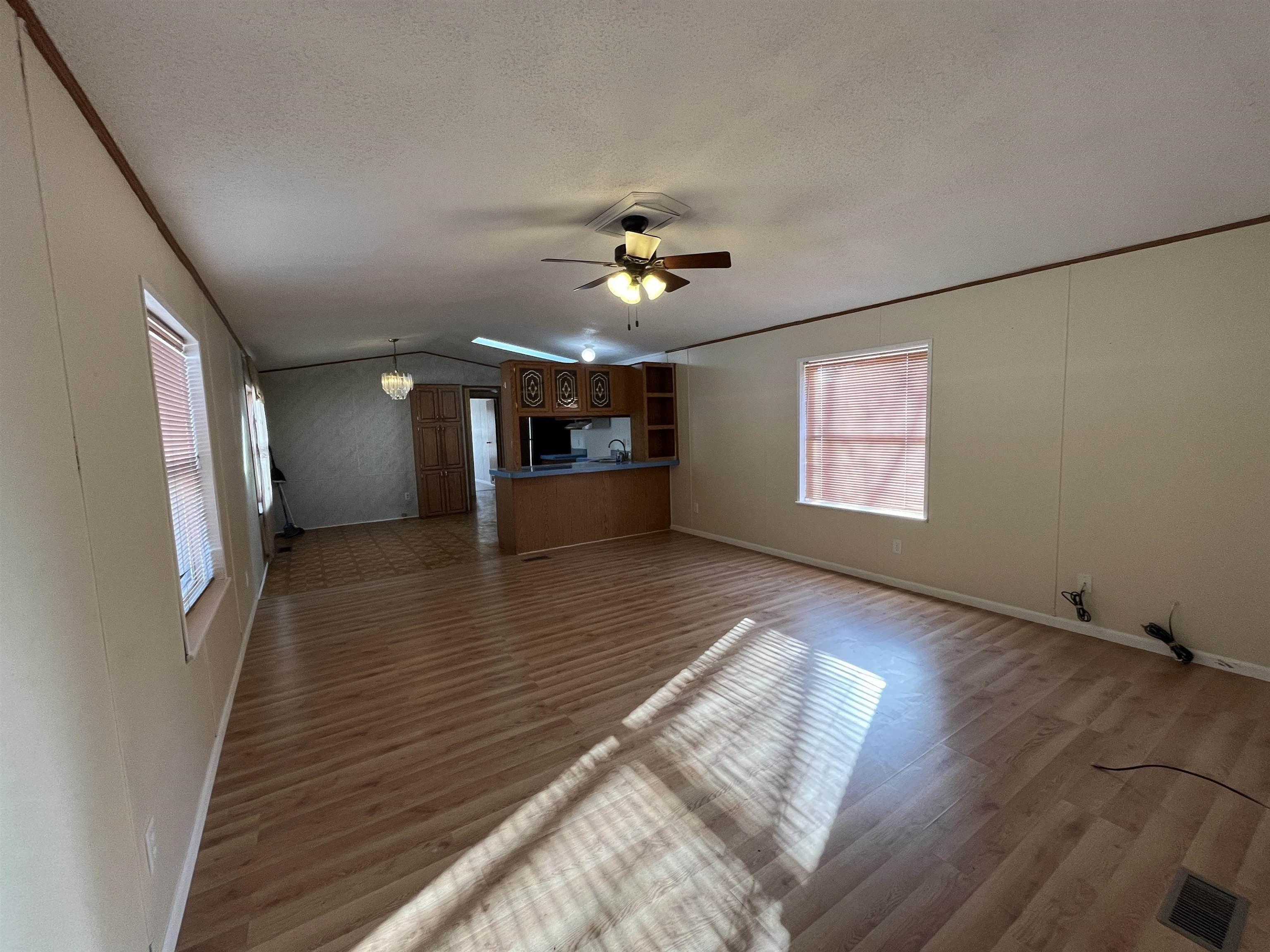
$55,000
3 beds • 2 baths • 1,216 sqft
Estimated Payment
$ 337 /mo. †
6.67%
APR for
30 yrs.
$642 in taxes
Change Loan Terms
-
Mobile/Manufactured Home
Property type -
$45.23
Price per square foot -
21-30 Years Old
Age
Explore this Property
Courtesy Of Berkshire Hathaway Home Services Amb RE Norfolk
(402) 371-3469
Property Features
-
Age21-30 Years Old
-
Architecture StyleOther
Home seller CENTURY 21 Affiliated
Get to know the neighborhood. A local affiliated CENTURY 21 office will help you set up tours, give advice, and negotiate with sellers.
CENTURY 21 Affiliated
(269) 888-1900Mortgage Calculator
Monthly Payment Breakdown
-
Principle and Interest
$283
-
Property Taxes
$53
-
Hazard Insurance
$0
-
Private Mortgage Insurance
$0
-
HOA Dues
$0
-
Total Monthly Payment:
$337
Calculators provided for estimating purposes only. Consult with your lender to determine precise payment requirements.
Schools
Norfolk Middle School
Grades 5-6 Public School
Norfolk, NE 68701
3.7 miles
1221 n 1st st
646 total students
15:1 Student teacher ratio
Washington Elementary School
Grades KG-4 Public School
Norfolk, NE 68701
1.9 miles
1205 s 2nd st
220 total students
14:1 Student teacher ratio
Norfolk Junior High School
Grades 7-8 Public School
Norfolk, NE 68701
2.3 miles
510 e pasewalk ave
628 total students
14:1 Student teacher ratio
Norfolk High School
Grades 9-12 Public School
Norfolk, NE 68701
3.3 miles
801 riverside blvd
1348 total students
16:1 Student teacher ratio
| Other Nearby Schools | Distance | Type | Grades | School Rating |
|---|---|---|---|---|
| Christ Lutheran School | 2.4 miles | Private | PK-8 | |
| Westside Elementary School | 2.6 miles | Public | KG-4 | C+
|
| Lincoln Elementary School | 2.6 miles | Public | PK-4 | C
|
| Grant Elementary School | 2.6 miles | Public | KG-4 | B
|
| Norfolk Catholic Elementary School | 2.8 miles | Private | PK-6 | |
| Norfolk Catholic High School | 2.9 miles | Private | 7-12 | |
| Jefferson Elementary School | 3.2 miles | Public | KG-4 | B
|
| Immanuel Lutheran School | 3.2 miles | Private | PK-8 | |
| Alternatives For Success School | 3.4 miles | Public | ||
| St Pauls Lutheran School | 3.5 miles | Private | PK-8 | |
| Bel Air Elementary School | 3.6 miles | Public | KG-4 | B-
|
| Eastern Learning Center | 4.8 miles | Public | ||
| Lutheran High Northeast | 4.9 miles | Private | 9-12 | |
| Woodland Park Elementary School | 5.8 miles | Public | KG-4 | D+
|
School information does not guarantee enrollment. School service boundaries are provided as a reference only, may change, and are not guaranteed to be accurate. Contact the school district directly to verify school enrollment eligibility.
Local area information for Norfolk, NE 68701

Tour the area
Schedule a
tour with a
personal guide
Norfolk, NE 68701
This community’s employment is highest in the administrative support and sales industries. The area’s overall household expenses are above the national average.

have children
Household Expenses vs National Average
Demographic facts
for Norfolk, NE 68701
Norfolk, NE 68701 has a population of 29,858 people in 12,500 households with a median age of 38.2 years old.

since the year 2010
Population is Trending down
households in 5 years
Community Population By Age
Community Population By Ethnicity
| White | 81% |
| Hispanic | 15% |
| Other | 7% |
| Native American | 2% |
| Black | 1% |
| Asian | 1% |
Economics
for Norfolk, NE 68701

Household Expenses vs National Average
Household by Income
Transportation to Work
- Drive 90%
- Work from Home 5%
- Walk or Bike 4%
- Public Transit 1%
Occupancy by Type
| Owned | 8,557 | 64% |
| Rented | 3,943 | 29% |
| Vacant | 896 | 7% |
White vs Blue Collar Jobs
| White Collar | 63% |
| Blue Collar | 37% |
Family & Education Facts
for Norfolk, NE 68701

Average Household Size
household
45.4%
Community Population By Education
| High School Graduate | 30% |
| Some College | 22% |
| Bachelors Degree | 19% |
| Associates Degree | 15% |
| Graduate Degree | 8% |
| Some High School | 6% |
Household Family Expenses vs National Average
Weather
for Norfolk, NE 68701
The weather for this area ranges from a high of 87° F in July to a low of 9° F in January

Average Temperature by Month
Average Temperature in Degrees Fahrenheit
Precipitation
| Precipitation (inch) |
Tour the area
Schedule a
tour with a
personal guide
There's more to learn about Norfolk, NE 68701!
Explore more
local area information
Copyright © 2025 Norfolk Board of Realtors. All rights reserved. All information provided by the listing agent/broker is deemed reliable but is not guaranteed and should be independently verified. Information being provided is for consumers' personal, non-commercial use and may not be used for any purpose other than to identify prospective properties consumers may be interested in purchasing. Information being provided is for consumers' personal, non-commercial use and may not be used for any purpose other than to identify prospective properties consumers may be interested in purchasing.
Data powered by Attom Data Solutions. Copyright© 2025. Information deemed reliable but not guaranteed.
This information is provided for general informational purposes only and should not be relied on in making any home-buying decisions. School information does not guarantee enrollment. Contact a local real estate professional or the school district(s) for current information on schools. This information is not intended for use in determining a person's eligibility to attend a school or to use or benefit from other city, town or local services.
† Based on a 30-year fixed rate of 3.38% with 20% down. The estimated payment is offered for convenience and is not an offer of credit. Due to market fluctuations, interest rates are subject to change at any time and without notice. Interest rates are also subject to credit and property approval based on secondary market guidelines. The rates shown are based on average rates for our best qualified customers. Your individual rate may vary. Rates may differ for FHA, VA or jumbo loans.

3207 S 12th St # 59
Norfolk, NE 68701
3207 S 12th St # 59
Norfolk
, NE 68701

Norfolk, NE 68701
Courtesy Of Berkshire Hathaway Home Services Amb RE Norfolk
Request Information
Norfolk, NE 68701
Courtesy Of Berkshire Hathaway Home Services Amb RE Norfolk
Request a tour of this property
Norfolk, NE 68701
Courtesy Of Berkshire Hathaway Home Services Amb RE Norfolk