Snode Street NE, Alliance, OH 44601
Price On Request
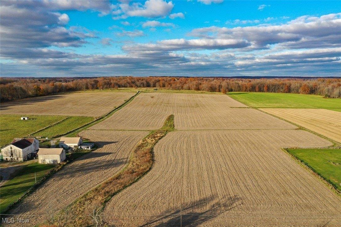
68 acres
-
Other Residential
Property type -
68 acres
Lot size
Explore this Property
Courtesy Of richard t. kiko agency, inc.
(330) 453-9187
Property Features
-
Architecture StyleOther
-
Lot Size68 Acres
Home seller CENTURY 21 Lakeside Realty
Get to know the neighborhood. A local affiliated CENTURY 21 office will help you set up tours, give advice, and negotiate with sellers.

CENTURY 21 Lakeside Realty
(330) 967-0621Schools
Lexington Elementary School
Grades KG-5 Public School
Alliance, OH 44601
0.7 miles
12333 atwater ave ne
328 total students
17:1 Student teacher ratio
Washington Elementary School
Grades KG-5 Public School
Alliance, OH 44601
6.9 miles
5786 beechwood ave
251 total students
14:1 Student teacher ratio
Marlington Middle School
Grades 5-9 Public School
Alliance, OH 44601
2.6 miles
10325 moulin ave ne
504 total students
17:1 Student teacher ratio
Marlington High School
Grades 9-12 Public School
Alliance, OH 44601
2.4 miles
10450 moulin ave ne
678 total students
16:1 Student teacher ratio
| Other Nearby Schools | Distance | Type | Grades | School Rating |
|---|---|---|---|---|
| Alliance Intermediate School @ Northside | 2.7 miles | Public | 4-6 | C+
|
| Regina Coeli School | 3.3 miles | Private | PK-5 | |
| Alliance Early Learning School | 3.6 miles | Public | PK-1 | |
| Good Shepherd Christian Academy | 3.7 miles | Private | 1-8 | |
| Alliance High School | 3.9 miles | Public | 9-12 | C-
|
| Marlboro Elementary School | 4.3 miles | Public | KG-5 | C-
|
| Alliance Elementary School At Rockhill | 4.5 miles | Public | KG-3 | C-
|
| Alliance Middle School | 5.2 miles | Public | 6-10 | B-
|
School information does not guarantee enrollment. School service boundaries are provided as a reference only, may change, and are not guaranteed to be accurate. Contact the school district directly to verify school enrollment eligibility.
Local area information for Alliance, OH 44601

Tour the area
Schedule a
tour with a
personal guide
Alliance, OH 44601
This community’s employment is highest in the administrative support and education industries. The area’s overall household expenses are below the national average.

have children
Household Expenses vs National Average
Demographic facts
for Alliance, OH 44601
Alliance, OH 44601 has a population of 33,809 people in 13,587 households with a median age of 41 years old.

since the year 2010
Population is Trending down
households in 5 years
Community Population By Age
Community Population By Ethnicity
| White | 84% |
| Black | 7% |
| Hispanic | 2% |
| Other | <1% |
| Asian | <1% |
| Native American | <1% |
Economics
for Alliance, OH 44601

Household Expenses vs National Average
Household by Income
Transportation to Work
- Drive 89%
- Work from Home 5%
- Walk or Bike 5%
- Public Transit 1%
Occupancy by Type
| Owned | 8,140 | 55% |
| Rented | 5,447 | 37% |
| Vacant | 1,298 | 9% |
White vs Blue Collar Jobs
| White Collar | 55% |
| Blue Collar | 45% |
Family & Education Facts
for Alliance, OH 44601

Average Household Size
household
42.8%
Community Population By Education
| High School Graduate | 47% |
| Some College | 18% |
| Bachelors Degree | 12% |
| Some High School | 10% |
| Graduate Degree | 6% |
| Associates Degree | 6% |
Household Family Expenses vs National Average
Weather
for Alliance, OH 44601
The weather for this area ranges from a high of 83° F in July to a low of 18° F in January

Average Temperature by Month
Average Temperature in Degrees Fahrenheit
Precipitation
| Precipitation (inch) |
Tour the area
Schedule a
tour with a
personal guide
There's more to learn about Alliance, OH 44601!
Explore more
local area information
Copyright © 2025 MLS Now. All rights reserved. All information provided by the listing agent/broker is deemed reliable but is not guaranteed and should be independently verified. Information being provided is for consumers' personal, non-commercial use and may not be used for any purpose other than to identify prospective properties consumers may be interested in purchasing. Information being provided is for consumers' personal, non-commercial use and may not be used for any purpose other than to identify prospective properties consumers may be interested in purchasing.
Data powered by Attom Data Solutions. Copyright© 2025. Information deemed reliable but not guaranteed.
This information is provided for general informational purposes only and should not be relied on in making any home-buying decisions. School information does not guarantee enrollment. Contact a local real estate professional or the school district(s) for current information on schools. This information is not intended for use in determining a person's eligibility to attend a school or to use or benefit from other city, town or local services.
† Based on a 30-year fixed rate of 3.38% with 20% down. The estimated payment is offered for convenience and is not an offer of credit. Due to market fluctuations, interest rates are subject to change at any time and without notice. Interest rates are also subject to credit and property approval based on secondary market guidelines. The rates shown are based on average rates for our best qualified customers. Your individual rate may vary. Rates may differ for FHA, VA or jumbo loans.

Snode Street NE
Alliance, OH 44601
Snode Street NE
Alliance
, OH 44601

Alliance, OH 44601
Courtesy Of richard t. kiko agency, inc.
Request Information
Alliance, OH 44601
Courtesy Of richard t. kiko agency, inc.
Request a tour of this property
Alliance, OH 44601
Courtesy Of richard t. kiko agency, inc.